City Energy Model
Background
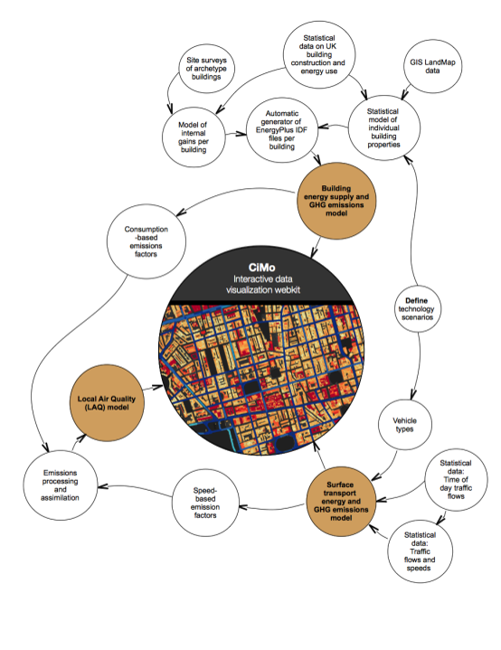
The City Energy Model (CiMo) is a bottom-up engineering model of energy demand, supply, and emissions from buildings and surface transport at the city scale. It owes its name to an intense multi-disciplinary effort of 3 post-docs, in 2013-14, during the final year of the phase 1 EECi.
This model was developed with support from the Center for Smart Infrastructure & Construction and EPSRC's Impact Acceleration Award (2016-2017), in close partnership with Improbable Inc., a technology company in London.
What is CiMo?
The EECi's City Model is a high-resolution exploratory tool, offering a spatially differentiated, hourly physics model of energy demand, supply, emissions, and air quality at the city scale. It brings together the individual contributions of EECi researchers in the buildings, transport, and energy modelling fields.
The model can provide new insights into data management of energy performance for city planning and design, comparative costing of greenhouse emissions and air pollution within cities, and the identification of energy use and emissions ‘hotspots’.
The City of Westminster, within central London, was chosen for the first pilot application due to its diversity of building types, transport services, and population. Westminster has a residential population of over 200,000 and a working population of over 600,000. Approximately 2.7 million road vehicles travel on its streets daily.
Buildings Analysis
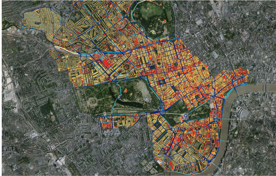
The analysis of buildings capitalised on several recent developments: physical characteristics of individual buildings in the UK can now be inferred from new research literature and statistical data (e.g. EPC/DEC building performance certificate data since 2010), and three-dimensional geometries of individual buildings within Westminster are available from geographic databases. The result is that each individual building can be represented by a physical model.
EECi researchers used the University of Cambridge’s Darwin High Performance Computing cluster to undertake annual, hourly energy simulations of each of the 100,000 representational building models in the City of Westminster.
Transport Analysis
Transport analysis provides an hourly model of the vehicle fleet travelling on the roads in Westminster and its composition by size, fuel, technology and speed. This enables a spatially-refined representation of technology and policy scenarios, now and in the future. Analysis of traffic flows by vehicle type, time of day and location is possible by automatic traffic counters, sensors in and alongside roads, connected in-car satellite navigation systems and fleet vehicle tracking.
The researchers combined models of powertrains in conventional, hybridised and electric vehicles with temporal-spatial traffic patterns to determine the distribution of energy use and emissions, from the street level to full city scale.
Environmental Impacts Analysis
The analysis of environmental impacts quantifies the effect of Westminster emissions sources on local air quality. The spatially resolved emissions from buildings and transport are processed in pollution dispersion models. As a result it is possible to identify whether emissions in Westminster lead to exceedances of regulatory limits on air quality under present day and alternative technology and policy scenarios.
The relative contribution of buildings and transport to concentrations of regulated air pollutants are evaluated and mitigation strategies designed to address pollution hotspots can be recommended.